

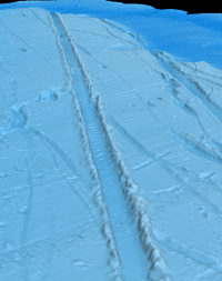
Perspective view of a relict iceberg
scour on the seafloor offshore of
South Carolina
Subtropical Icebergs & Paleocirculation of the North Atlantic
Evidence of extensive seafloor iceberg scouring suggests that massive icebergs, as much as 300 m thick, drifted south along the coast of the southern U.S., reaching as far as southern Florida during deglaciation. High resolution coupled ocean-atmosphere-sea ice numerical model simulations developed by my collaborator Dr. Alan Condron (U.Mass-Amherst) show that that meltwater from the North American ice sheet would have regularly reached the latitude of South Carolina during the winter season, meaning that icebergs would have been a regular occurrence along the coast here. The glacial ocean circulation model also shows that short-lived (<1yr duration), large volume meltwater floods, similar to catastrophic glacial lake outburst floods, would have been required to transport the icebergs to southern Florida. During these large meltwater flood events, the nearshore surface ocean current would have been much colder and fresher, with a reversal in direction of 180° from the typically northward flowing Gulf Stream, and there would have been a sudden appearance of massive icebergs along the coast, from South Carolina to the Florida Keys. These studies also help us understand how future ice sheet melt from Greenland will be distributed through out the ocean and may affect global climate. It has traditionally been thought that ice sheet melt in the North Hemisphere was directly input to the subpolar ocean, where it may have a major impact on ocean convection and drive large shifts in climate. Our new research, published in Nature Geoscience, shows that much of the fresh water from ice sheet melt may be redistributed by coastal boundary currents and circulated through subtropical regions prior to reaching the subpolar ocean. This implies the mechanisms of abrupt climate change may be more complex than previously thought.
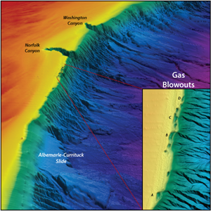
Geologic Controls on Slope Stability of the U.S. Atlantic Margin
The continental slope of the U.S. Atlantic margin is characterized by numerous submarine landslides and extensive seabed fluid expulsion features. Within the Mid-Atlantic region, the Currituck submarine landslide complex located offshore North Carolina is one of the most pronounced geomorphic features of the margin, having excavated and redeposited sediment over an area greater than 6500 km2 along continental slope and upper rise. To the north, large scale (~4 km long, ~1 km wide, ~50 m deep), en echelon elongated mega-pockmark features discovered on the outer shelf offshore of Virginia and North Carolina provide evidence of a strongly overpressured system that may represent incipient slope failure. Chirp subbottom data, high-resolution swath bathymetry, AUV dives and geochemical studies across these features show that gas is trapped beneath a shelf-edge delta deposit that exhibits progressive deformation indicative of downslope creep and that methane is actively venting along the blowout walls. These neighboring parts of the margin highlight the distinct variations in slope morphology and provide insight into the role of sedimentation patterns, fluid flow and gas accumulation in the development of slope instability. The style of slope failure , whether localized along steep canyon walls or more widespread, regional scarps, appears to be directly linked to the antecedent geology and margin morphology. Integrated analysis of of new high-resolution multichannel seismic (MCS) reflection profiles acquired in collaboration with the USGS, multibeam bathymetry data, and vintage industry MCS profiles profiles are being used to reconstruct the geologic framework of the margin and better understand the preconditioning factors for slope failure.
Paleoclimate & Sea Level Fluctuations along the Arctic Alaskan margin
The Arctic Ocean and surrounding margins play a critical role in the Earth’s climate system, yet the paleoclimate, ice extent during recent glaciations, and deglacial history of the region remains poorly constrained. Chirp subbottom profiling, along with sediment cores across the Chukchi shelf has provided evidence of extensive paleodrainage networks formed during periods of lowered sea level. The data also suggest there were large outbursts of glacial meltwater and iceberg discharge events that appear to be sourced from the northwestern Alaskan margin during the most recent deglaciation; however, previous onshore studies have argued for severely limited to nonexistent ice cover across northern Alaska. This seeming contradiction highlights the role of climatic variability across the region and suggests a greater extent of continental glaciation than previously recognized. Constraining Arctic ice extent is critically important for the development of global climate and circulation models that allow us to increase understanding and predictive capacity of global responses to past, present and future climate shifts.
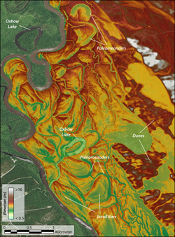
Paleomeanders, paleodunes and oxbow lakes
along the Great PeeDee River
Through investigations of the geologic framework, dune stratigraphy and fluvial morphology along the Great Pee Dee River, we are examining the influence of shifting climate, sea level fluctuations and tectonic deformation on the evolution of the landscape. With this focus, we are collecting a suite of geophysical and geological data along the Great Pee Dee River. High resolution LiDAR topography, Chirp subbottom data from the river, GPR across the floodplain and dunes, sediment cores along these subsurface profiles are being used to investigate the complex patterns of river migration in response to changes in climate, sea level and tectonics. This project has an integral undergraduate research component, as field work is regularly conducted as part of MSCI 444L: Long Term Climate and Landscape Change, providing students with hands-on research experience.
Geologic Framework, Nearshore Hardbottom Habitats & Submarine Groundwater
The nearshore environment along South Carolina's Grand Strand is comprised of thin, patchy sediment cover amongst extensive hardbottom reef areas that serve as critical habitats. Understanding the complex interactions of physical, geological and biological processes that occur around hardbottom reefs will allow fisheries and coastal managers to develop improved ecosystem-based approaches to beach management. Investigating the linkages between framework geology, inner shelf morphology and beach behavior goes hand in hand with this to provide a more comprehensive understanding of sediment-starved coastal regions. Nearshore submarine groundwater discharge is also an important contributor of nutrient fluxes to the Long Bay, SC region that can have a significant impact on the quality of local habitats. Working several other researchers at SCMSS, we are using a combination of geophysical (Electrical Resistivity, Chirp Subbottom) and geochemical (Radon-222 and nutrient sampling) techniques to characterize geologic controls on submarine groundwater discharge and quantify discharge rates and nutrient fluxes in the coastal region.
Coastal & Fluvial Morphology: An example from the Duplin River, Georgia
The Duplin River is an ebb-domintated, salt marsh drainage system west of Sapelo Island, Georgia, that is part of the Georgia Coastal Ecosystems Long Term Ecological Research (GCE-LTER) site. With no riverine input, flow in the Duplin is dependent on local surface run off, groundwater discharge and tidal flushing. Repeat multibeam bathymetry surveys within this system provide insight into sediment transport, current dynamics, and the migration of bottom features. Integration of topographic LiDAR data, vegetation patterns, sediment composition, groundwater inputs and planform river morphology also aid investigations into sediment storage and transport within the system.
 |
 |
Last Update:
11/26/2014